Sunday, October 25, 2015

My Gust photo 
Contact ;- Email;- lasantha777@hotmail.com
 Mobile;- +94 777 856 771


Tuesday, October 20, 2015

Udawalawa elephant orphanage milk feeding
Contact ;- Email;- lasantha777@hotmail.com
 Mobile;- +94 777 856 771
 

Tuesday, June 30, 2015

BUNDALA BIRD SANCTUARY in SRI LANKA
Contact ;- Email;- lasantha777@hotmail.com
 Mobile;- +94 777 856 771


 Bundala National Park is an internationally important wintering ground in Sri Lanka for migratory water birds. Bundala harbors 197 species, the highlight being the Greater Flamingo, which migrate in large flocks. Bundala was designated a wildlife sanctuary in 1969 and redesignated to a national park on 4 January 1993. In 1991 Bundala became the first wetland to be declared as a Ramsar site in Sri Lanka. In 2005 the national park was designated as abiosphere reserve by UNESCO, the fourth biosphere reserve in Sri Lanka. The national park is situated 245 km southeast of Colombo.

The area mainly underlain with hornblende biotite gneiss of the eastern Vijayan series. The low country dry zone climate prevails in the area. Bundala area receives 1,074 mm of annual rainfall. Although the area receives substantial rainfall during the North-eastern monsoon season, dry climate persists rest of the year. The proximity to the Indian Ocean helps to ameliorate the temperatures. The mean annual temperature is around 28.0°C. But temperature rise in the months of April, May and June. The national park have a high relative humidity ratio of 80%. The national park consists four lagoons, Bundala lagoon of 520 ha, Embilikala lagoon of 430 ha, Malala lagoon 650 ha and Koholankala lagoon of 390 ha.

The Phytoplankton in all the lagoons is dominated by blue-green algae including species such as Macrocystis Nostoc, Oscillatoria. Hydrilla is in abundance in lagoons such as Embilikala and Malala. Water hyacinth, water lilies, and Typha angustifolia reed beds are found in the marshes and streams. The vegetation mainly consists of Acacia scrubs including Dichrostachys cinerea, Randia dumetorum, Ziziphus sp., Gymnosporia emarginata, Carissa spinarum Capparis zeylanica and Cassia spp.. The trees of the forest are Bauhinia racemosa Salvadora persica Drypetes sepiaria, and less common Chloroxylon swietenia Azadirachta indica, and Feronia limonia. plants thrive in the national park's environmental conditions. Salicornia brachiata and Halosarcia indica are examples of salt-tolerant plants. Lumnitzera racemosa trees found the small mangrove area.

Bundala is an important bird sanctuary. About 100 species of water birds inhabit the wetland habitats in Bundala, half of them being migrant birds. Greater Flamingo which visits in large flocks of over 1,000 individuals, from Rann of Kutch of India is being the highlight in the past. Other water birds which are present in large numbers include Lesser Whistling Duck, Garganey, Little Cormorant, Indian Cormorant, Grey Heron, Black-headed Ibis, Eurasian Spoonbill Asian Openbill, Painted Stork, medium sized waders, Tringa subspecies, and small waders, Charadrius subspecies. Black-necked Stork, Lesser Adjutant and Eurasian Coot are rare birds inhabit in the national park.

The forest is an important habitat for the endangered Sri Lankan Elephant, the largest subspecies of Asian Elephant. Sri Lankan Sambar Deer, Sri Lankan Leopard, Wild boar, Indian Gray Mongoose, Sri Lankan Sloth Bear, Sri Lankan Axis Deer, Small Indian Civet, Golden Jackal, and Indian Crested Porcupine are the other mammals found in the park.
BENTHOTA
Contact ;- Email;- lasantha777@hotmail.com
 Mobile;- +94 777 856 771


Bentota is a Sri Lankan coastal city located on the southern tip of the Galle District of the Southern Province, about 7–8 kilometres (4.3–5.0 mi) south of Beruwala on the A2 highway. Its population is estimated to be between 25,000-50,000. The name comes from a mythical story which dates back to kings time saying a demon called Bem ruled this river (tota = river bank).
Bentota is a tourist attraction, with a local airport (Bentota River Airport) and a handful of world-class hotels. It is a destination for watersports. It is the hosting land for the famous Sri Lankan Jeweler Aida. Bentota also delivers an ancient art of healing called Ayurveda. Bentota is famous for its toddy production, an alcoholic beverage made out of coconut nectar

Monday, June 29, 2015

BATTICALOA
Contact ;- Email;- lasantha777@hotmail.com
 Mobile;- +94 777 856 771


Batticaloa is a city in the Eastern province of Sri Lanka. It is the seat of the Eastern University of Sri Lanka. It is on the east coast, 69 miles (111 km) south by south east of Trincomalee, and is situated on an island.
Batticaloa is a Portuguese derivation. The original name of the region being the Sinhalese "Madda Kalapuwa" (translation: Mud Lagoon). This is assumed to have been adapted by the later Tamil settlers.
According to Mattakallappu Manmiyam the word Mattakkallpu consists Tamil words "Mattu" means honey or Matta-derived from "Mattam" means (Flat) and geographical name KaLappu. Mukkuwa named this place as KaLappu-Mattam or boundary of lagoon later it became Matta-Kallappu or Flat Lagoon. Similarly the Mattu-Kallppu or "Confluence of Honey River" became Mattakkallappu. Batticaloa is in the eastern coast of Sri Lanka on a flat coastal plain boarded by the Indian Ocean in the east occupies the central part of the eastern Sri Lanka. Its average elevation is around 5 meters. Scenic beauty of the Batticaloa is the Lagoons. Batticaloa district has three lagoons such as Batticaloa Lagoon, Valaichchenai Lagoon, and Vakari (Panichch ankerni) Lagoon. Among these lagoon, Batticaloa Lagoon is the largest lagoon and has 56 km long 162 square km area, extending from Pankudaweli in North and Kalmunai in South.
The earliest historical artifacts are a dagaba and Chatra from the Ruhuna kingdom of King Kavantissa (1st century BC), found in the Dutch fort built in the seventeenth century CE. Many archeological sites dating to pre-Christian times have been found in this region. Thus Lankavihara, Roththei (Roththa) temple, Kinnaragala, Rahathgala (Shanthamalai), Veheragalkanda (Pulukunai), eluvamulla (Pullumuilai), and Taaththon Kovil, are some sites identified and listed by the Government archaeological survey. Many towns of the area show toponymic evidence, as well as evidence from stone inscriptions, of ancient sites related to 'Seruvavila' and other Buddhist shrines of the area. Although a large number of ancient historical sites have been identified, archaeological excavations and detailed studies have been very limited. A map of the Buddhist sites in the eastern coastal belt near Batticaloa and extending towards Trincomalee has been given in a "Buddhist Times" publication.


Sunday, June 21, 2015


Arugam Bay Surfing Paradise
Contact ;- Email;- lasantha777@hotmail.com  Mobile;- +94 777 856 771 2


5435
Arugam Bay is a bay situated on the Indian Ocean in the dry zone of Sri Lanka's southeast coast. The bay is located 320 km due east of Colombo. "Ullai" as Arugam Bay is locally known is a popular surfing and tourist destination. Many of the buildings were destroyed in the 2004 tsunami. The Government's Min. of Defense CCD (Coastal Conservation Dept.) created what is now described as Arugam's second "Tsunami" end September 2011, when all beach side structures where demolished by bulldozers. Due to its popularity among tourists, the area has managed a slow recovery by private initiatives only. As late as 2011 no help has been received from any official source or international organizations. An exception is uncoordinated support for fishing folk as well as many school rebuilding programs, resulting in a continuation to provide only separatist schools for each community. Although there is a huge demand for an international school, one huge new building donated by the people of Japan remains largely unoccupied since the grand 'opening' ceremony in 2007.

The bay hosts a large fleet of fishing boats which operates off the beach. Many organizations donated boats after the tsunami and as a result there are far more fishing boats than ever before. The main beach is a bit dirty as it is used as a garbage dump and a toilet by some locals. Nearby beaches are more esthetically pleasing and also have excellent waves. Arugam Surf Point has a very long, consistent, sectiony right hand break. In mid 2010 ASP hosted its first international surf contest in the Bay. The winner of such was Australian Julian Wilson. ASP repeated their contest tour in 2011 added a women's competition to the men's long board championship at Arugam Bay.Many organizations claim to have done extensive work in the area. No notable progress can be observed locally and on close inspection, as late as New Year's Day, 2010. The main road, shown below in 2004 still looked the very same at the end of 2009. Despite calls for a walking street contractors have recently (September, 2010)completed construction of a fast trunk road through the hamlet. Repeating the mistakes made in other seaside tourist resorts such as Negombo and Hikkaduwa. US 'Mercy Corps' has been the most active of any organization. Funded by Oprah Winfrey's 'Angel Network', following a huge fund-raising TV series in the United States. Sadly, none of their projects survived the first year of operation. A new bridge has been constructed by USAID. It was opened for traffic in 2008. It replaced the 1960s, original landmark box girder construction linking Arugam Bay with Pottuvil. At km 312 on the main A4 (the famous Colombo High Level Rd. - PottuVille), an excellent shortcut side road exists, which ends up in the very middle of Arugam Bay itself. This picturesque drive avoids the dusty town of Pottu Ville. Also no bridges need to be crossed. Raising questions regarding the wisdom for the need of the so-called 'high tech' USAID bridge construction. There is excellent elephant viewing nearby, incl. on this mentioned jungle road and the surrounding lagoon, as well as two types of monkeys wandering around the area.
The nearby (4 km) Muslim village of Pottuvil is the center of commerce and transportation while tourist accommodations lie along the beach to the south of Pottuvil Arugam Bay (4 km) is also the gateway and the only road access to the Yala East National Park. This area is known as Kumana (44 km), to be reached via the Sinhalese settlement of Panama (17 km) and the shires at Okanda (32 km). Sources of further, up-to-date local information: Arugam Bay has its own insiders, veteran and fan club with just 777 members end 2008. History was made on election day, 26 January 2010. The Community page Facebook page "Arugam Surf" managed to attract more than 10,000 fans. Making it the fasted growing non political Facebook page in Sri Lanka. By November 2011, Sri Lanka's first and oldest FB fan page attracted more than 60,000 loyal members. Remarkable how much global interest this small, remote hamlet of just 2,500 residents seems to generate.

Monday, May 11, 2015

Ayubowan !!! Welcome !!!
Sri Lankalasantha Tours, I'm Tour Operator and Travel Agent in Sri lanka. Our Staff always giving the best service to the foreigners who visiting to this land of paradise for their vacation. We have comfortable cars and vans with qualified, safely and professional drivers. Sri Lanka is amazing diversity of scenery. It is possible to pass brilliant green paddy field, sun-bronzed beaches, ruined cities, small lively villages..

Contact  : Mobil;- +94777856771   Email :- lasantha777@hotmail.com

My gust photo


Sigiriya (Lion's rock ) is a large stone and ancient rock fortress and palace ruin in the central Matale District of Sri Lanka, surrounded by the remains of an extensive network of gardens, reservoirs, and other structures. A popular tourist destination, Sigiriya is also renowned for its ancient paintings (frescos), which are reminiscent of the Ajanta Caves of India. It is one of the eight World Heritage Sites of Sri Lanka. It is also declared by UNESCO as the 8th Wonder of the World. Sigiriya may have been inhabited through prehistoric times. It was used as a rock-shelter mountain monastery from about the 5th century BC, with caves prepared and donated by devotees of the Buddhist Sangha. According to the chronicles as Mahavamsa the entire complex was built by King Kashyapa (AD 477 – 495), and after the king's death, it was used as a Buddhist monastery until 14th century. The Sigiri inscriptions were deciphered by the archaeologist Senarath Paranavithana in his renowned two-volume work, published by Cambridge, Sigiri Graffiti and also Story of Sigiriya.
Location and geographical features
Sigiriya is located in the Matale District, Central Province in the Central Province of Sri Lanka. It is within the cultural triangle, which includes five of the eight world heritage sites in Sri Lanka. The Sigiriya rock is a hardened magma plug from an extinct and long-eroded volcano. It stands high above the surrounding plain, visible for miles in all directions. The rock rests on a steep mound that rises abruptly from the flat plain surrounding it. The rock itself rises approximately 370 m (1,214 ft) above sea level and is sheer on all sides, in many places overhanging the base. It is elliptical in plan and has a flat top that slopes gradually along the long axis of the ellipse
History
In 477 CE, prince Kashyapa seized the throne from King Dhatusena, following a coup assisted by Migara, the king’s nephew and army commander. Kashyapa, the king’s son by a non-royal consort, usurped the throne from the rightful heir, Moggallana, who fled to South India. Fearing an attack from Moggallana, Kashyapa moved the capital and his residence from the traditional capital of Anuradhapura to the more secure Sigiriya. During King Kashyapa’s reign (477 to 495), Sigiriya was developed into a complex city and fortress. Most of the elaborate constructions on the rock summit and around it, including defensive structures, palaces, and gardens, date back to this period. The Mahavamsa, the ancient historical record of Sri Lanka, describes King Kashyapa as the son of King Dhatusena. Kashyapa murdered his father by walling him up alive and then usurping the throne which rightfully belonged to his brother Mogallana, Dhatusena's son by the true queen. Mogallana fled to India to escape being assassinated by Kashyapa but vowed revenge. In India he raised an army with the intention of returning and retaking the throne of Sri Lanka which he considered to be rightfully his. Knowing the inevitable return of Mogallana, Kashyapa is said to have built his palace on the summit of Sigiriya as a fortress and pleasure palace. Mogallana finally arrived and declared war. During the battle Kashyapa's armies abandoned him and he committed suicide by falling on his sword.

Archaeological remains and features
In 1831 Major Jonathan Forbes of the 78th Highlanders of the British army, while returning on horseback from a trip to Pollonnuruwa, came across the "bush covered summit of Sigiriya". Sigiriya came to the attention of antiquarians and, later, archaeologists. Archaeological work at Sigiriya began on a small scale in the 1890s. H.C.P. Bell was the first archaeologist to conduct extensive research on Sigiriya. The Cultural Triangle Project, launched by the Government of Sri Lanka, focused its attention on Sigiriya in 1982. Archaeological work began on the entire city for the first time under this project. There was a sculpted lion's head above the legs and paws flanking the entrance, but the head broke down many years ago.
Frescoes
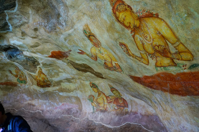
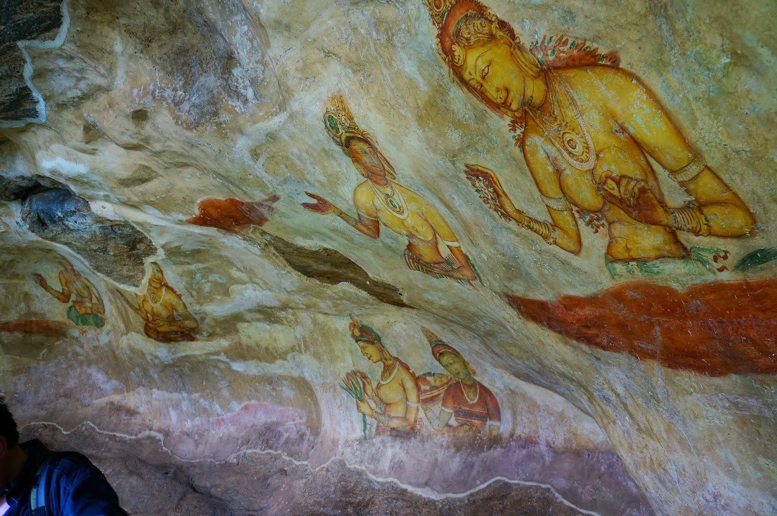
John Still in 1907 suggested, "The whole face of the hill appears to have been a gigantic picture gallery... the largest picture in the world perhaps". The paintings would have covered most of the western face of the rock, covering an area 140 meters long and 40 meters high. There are references in the graffiti to 500 ladies in these paintings. However, many more are lost forever, having been wiped out when the Palace once more became a monastery − so that they would not disturb meditation. Some more frescoes, different from the popular collection, can be seen elsewhere on the rock surface, for example on the surface of the location called the "Cobra Hood Cave". Although the frescoes are classified as in the Anuradhapura period, the painting style is considered unique the line and style of application of the paintings differing from Anuradhapura paintings. The lines are painted in a form which enhances the sense of volume of the figures. The paint has been applied in sweeping strokes, using more pressure on one side, giving the effect of a deeper colour tone towards the edge. Other paintings of the Anuradhapura period contain similar approaches to painting, but do not have the sketchy lines of the Sigiriya style, having a distinct artists' boundary line. The true identities of the ladies in these paintings still have not been confirmed. There are various ideas about their identity. Some believe that they are the wives of the king while some think that they are women taking part in religious observances. These pictures have a close resemblance to some of the paintings seen in the ajanta caves in India
The Mirror Wall
Originally this wall was so well polished that the king could see himself whilst he walked alongside it. Made of a kind of porcelain, the wall is now partially covered with verses scribbled by visitors to the rock. Well preserved, the mirror wall has verses dating from the 8th century. People of all types wrote on the wall, on varying subjects such as love, irony, and experiences of all sorts. Further writing on the mirror wall has now been banned.
The gardens
The Gardens of the Sigiriya city are one of the most important aspects of the site, as it is among the oldest landscaped gardens in the world. The gardens are divided into three distinct but linked forms: water gardens, cave and boulder gardens, and terraced gardens.
The water gardens
The water gardens can be seen in the central section of the western precinct. Three principal gardens are found here. The first garden consists of a plot surrounded by water. It is connected to the main precinct using four causeways, with gateways placed at the head of each causeway. This garden is built according to an ancient garden form known as char bhag, and is one of the oldest surviving models of this form.
The second contains two long, deep pools set on either side of the path. Two shallow, serpentine streams lead to these pools. Fountains made of circular limestone plates are placed here. Underground water conduits supply water to these fountains which are still functional, especially during the rainy season. Two large islands are located on either side of the second water garden. Summer palaces are built on the flattened surfaces of these islands. Two more islands are located farther to the north and the south. These islands are built in a manner similar to the island in the first water garden.
The third garden is situated on a higher level than the other two. It contains a large, octagonal pool with a raised podium on its northeast corner. The large brick and stone wall of the citadel is on the eastern edge of this garden. The water gardens are built symmetrically on an east-west axis. They are connected with the outer moat on the west and the large artificial lake to the south of the Sigiriya rock. All the pools are also interlinked using an underground conduit network fed by the lake, and connected to the moats. A miniature water garden is located to the west of the first water garden, consisting of several small pools and watercourses. This recently discovered smaller garden appears to have been built after the Kashyapan period, possibly between the 10th and 13th centuries.
The boulder gardens
The boulder gardens consist of several large boulders linked by winding pathways. The gardens extend from the northern slopes to the southern slopes of the hills at the foot of Sigiriya rock. Most of these boulders had a building or pavilion upon them; there are cuttings that were used as footings for brick walls and beams. The audience hall of the king was situated in the boulder garden, the remains of which are seen on the flattened and polished summit of a large boulder. There is also a five-meter-long granite throne in this hall. The throne is carved from the boulder itself, and is not separated from it. Another notable feature in the boulder garden is the Cistern rock, named after a large, carved cistern atop it. A large archway, created by two boulders, provides access to the terraced gardens.
The terraced gardens
The terraced gardens are formed from the natural hill at the base of the Sigiriya rock. A series of terraces rises from the pathways of the boulder garden to the staircases on the rock. These have been created by the construction of brick walls, and are located in a roughly concentric plan around the rock. The path through the terraced gardens is formed by a limestone staircase. From this staircase, there is a covered path on the side of the rock, leading to the uppermost terrace where the lion staircase is situated.